Glendale sits at roughly 1,150 feet in the Salt River Valley, where the subsurface tells a story of ancient floods and desert deposition. For the nearly 250,000 residents and the commercial development pushing west past the Loop 101, that story matters. A soil mechanics study here is not a generic check-box; it deciphers the interplay between stiff caliche layers, pockets of loose silty sand, and the expansive clays that have caused millions in slab distress across Arrowhead Ranch. When we run a full program—sampling with SPT drilling through the cemented horizons and classifying fines via Atterberg limits in our ISO 17025-accredited lab—the numbers dictate everything from footing width to the calcium content in a stabilization mix. The goal is to take the archive of the basin’s geology and translate it into a practical bearing capacity that holds up under Glendale’s summer heat and the occasional monsoon downpour.
A soil mechanics study in Glendale is not about finding perfect ground—it’s about quantifying the imperfection so the structure can accommodate it without distress.
Our approach and scope
Local considerations
The Salt River Valley floor beneath Glendale is underlain by a complex sequence of interbedded gravels, clays, and evaporite deposits, with groundwater in some neighborhoods perched within 15 feet of grade. Expansive clay mapped as the Laveen or Cashion series can swell more than 4 percent under a wetting front, lifting lightly loaded slabs and cracking partition walls. During the seismic evaluation required by the City of Glendale under the IBC, the soil mechanics study must estimate cyclic softening potential in loose granular lenses—Seed & Idriss simplified procedures still anchor the analysis—because a magnitude 6.5 event on a nearby fault like the White Tank system could trigger settlement of several inches. Caliche layers confuse the picture: they drill like rock but dissolve under prolonged irrigation, creating voids. The only defense is a site-specific report that doesn’t assume homogeneity.
Reference standards
ASTM D1586 – Standard Test Method for Standard Penetration Test (SPT), ASTM D2487 – Standard Practice for Classification of Soils for Engineering Purposes (USCS), IBC 2021 – International Building Code (Chapter 18), ASCE 7-22 – Minimum Design Loads for Buildings
Related services
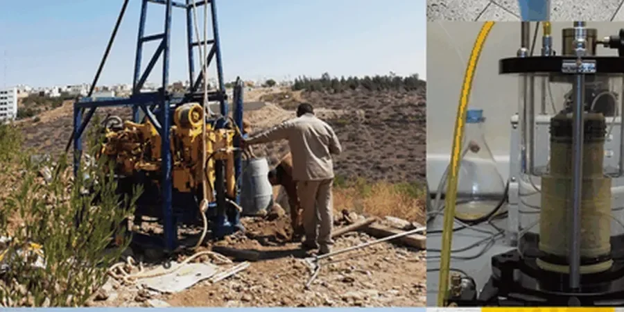
Comprehensive Field Exploration
Rig-mounted SPT borings, CPT soundings, and test pits to log stratigraphy, recover disturbed and undisturbed samples, and measure groundwater conditions across the Phoenix metro’s basin-fill geology.
Advanced Laboratory Testing
Triaxial shear, one-dimensional consolidation, swell pressure, and chemical analysis performed under ISO 17025 protocols to define strength parameters, settlement magnitude, and sulfate aggression potential for concrete.
Foundation Engineering Report
A stamped document delivering allowable bearing capacity, anticipated settlement, slab-on-grade recommendations, lateral earth pressures, and seismic site class per IBC—ready for City of Glendale plan review submittal.
Typical parameters
Common questions
What does a soil mechanics study in Glendale typically cost for a single-family home?
For a standard residential lot with two borings to 15 or 20 feet plus basic lab testing, the fee usually ranges between US$3,260 and US$5,970 depending on access, depth, and whether expansive soil or corrosivity suites are required by the structural engineer.
How deep do you have to drill for a Glendale subdivision preliminary report?
Preliminary geotechnical investigations for subdivisions generally extend borings to at least 25 or 30 feet, or deeper if soft zones are encountered within the basin-fill deposits. The depth must satisfy IBC requirements for the site class determination and provide enough stratigraphic data to lay out streets, utilities, and lot-specific foundation criteria.
Does a soil mechanics study include a seismic site class determination?
Yes. We measure the average shear-wave velocity in the upper 100 feet either through direct downhole methods or by correlating SPT N-values per ASCE 7-22. The resulting Site Class (C, D, or occasionally E in deeper alluvium) feeds directly into the structural design spectrum.
What happens if you encounter caliche during the boring?
Caliche is common across Glendale and can range from weakly cemented silt to rock-hard duripan. We log its thickness and hardness, switch to core-barrel sampling if necessary, and evaluate whether it can serve as a bearing stratum. We also test for dissolution potential, because irrigation water can soften some caliche horizons over time and cause differential settlement.