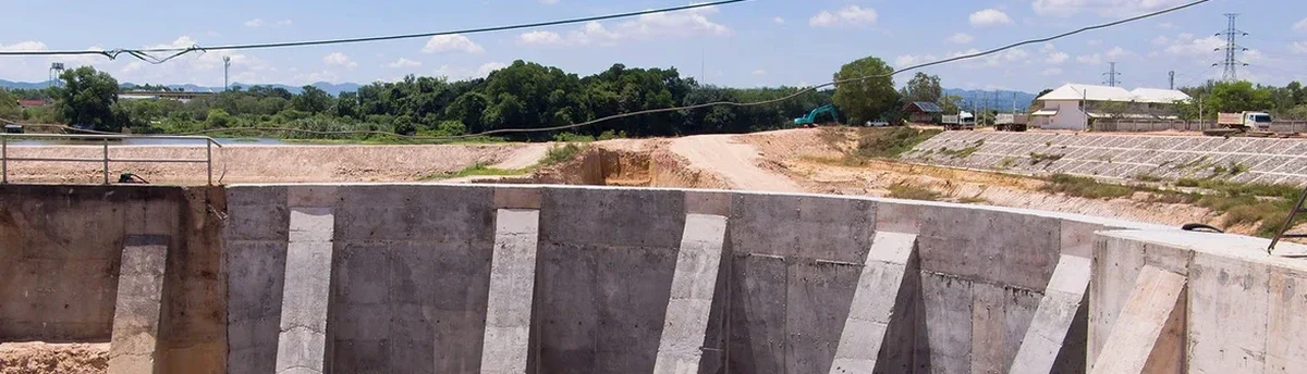
Glendale sits at roughly 1,150 feet above sea level, on the broad Salt River floodplain where the subsurface alternates between coarse river deposits and hard, cemented caliche. The city added nearly 14,000 residents between 2020 and 2023, fueling apartment and mixed-use projects that dig deeper than the area has seen before. When an excavation goes past 15 feet next to a 60-year-old strip mall on Glendale Avenue, the margin for error disappears. We set up inclinometer casings behind the shoring, place optical survey points on adjacent sidewalks, and install vibrating-wire piezometers to track groundwater that sometimes perches atop the caliche. This isn't just compliance with IBC Chapter 33; it's the difference between catching a 0.3-inch displacement early and arriving Monday morning to a cracked foundation. In our experience, the cemented soils here hold well until they don't—and that transition can be sudden, which is why we also lean on deep excavation design insights to calibrate alert thresholds specific to the site stratigraphy.
In Glendale's cemented soils, the real hazard isn't gradual deformation; it's the sudden loss of apparent cohesion when a caliche lens gets undercut.
Our approach and scope
Local considerations
The most common mistake we see on Glendale projects is treating the monitoring plan as a checkbox deliverable instead of a live decision tool. A crew will install the inclinometer casing, take one baseline reading, and then ignore the data until a problem is obvious from the street. By then, the shoring has already yielded beyond its service limit, and the repair costs triple. Another recurring failure: not extending the settlement monitoring far enough from the excavation. In the silty sands along the Agua Fria corridor, the settlement trough can stretch 1.5 times the excavation depth away from the wall, well past what a quick rule-of-thumb suggests. We also see projects where nobody correlates the piezometer data with the excavation sequence—a perched water pocket gets breached, the toe of the slope saturates, and the inclinometer shows a shear plane developing within 48 hours. Having the instruments in the ground is only half the job; the other half is having someone who reads the story the data is telling, especially where the caliche contact creates a hydraulic boundary that concentrates pore pressure.
Reference standards
ASCE 7-22 (Minimum Design Loads and Associated Criteria for Buildings and Other Structures), IBC 2024 Chapter 33 (Safeguards During Construction), ASTM D6230 (Standard Practice for Monitoring Well Installation), ASTM D653 (Terminology Relating to Soil, Rock, and Contained Fluids), FHWA GEC No. 4 (Ground Anchors and Anchored Systems), OSHA 29 CFR 1926 Subpart P (Excavations)
Related services
Inclinometer and ShapeArray profiling
Vertical casing installed behind soldier pile or secant walls, surveyed with a traversing probe or fixed-string ShapeArray to detect shear displacements and confirm the depth of any movement zone.
Surface and building settlement arrays
Deep-rod settlement points anchored below the zone of influence, monitored with digital levels or automated total stations; combined with crack gauges on brittle finishes and masonry walls within the influence envelope.
Piezometer and groundwater monitoring
Vibrating-wire piezometers placed at multiple depths to capture perched water on the caliche interface, with barometric compensation and real-time alerts when pore pressure exceeds dewatering design assumptions.
Real-time data management and threshold alerts
Cellular data loggers push readings to a web platform accessible by the contractor, geotechnical engineer, and owner; automated SMS and email alerts trigger at predefined green, amber, and red movement thresholds.
Typical parameters
Common questions
What is the typical cost range for geotechnical excavation monitoring on a Glendale commercial project?
For a mid-rise excavation lasting two to four months with inclinometers, settlement points, and piezometers, the instrumentation and monitoring service typically runs between US$870 and US$2,290 per week, depending on the number of instruments, reporting frequency, and whether automated total stations are required. A fixed lump sum for a defined monitoring period can also be structured.
How deep does an excavation need to be in Glendale before IBC requires a monitoring program?
IBC Section 3304 triggers monitoring when an excavation extends below the level of an adjacent foundation and the site is within the zone of influence. In Glendale's soil profile, where loose silts underlie the caliche crust, we typically recommend instrumentation for any cut deeper than 12 feet that is within 20 feet of an existing structure. The city's development services department may also require a preconstruction condition survey and monitoring plan as part of the shoring permit submittal.
How quickly can your team deploy instruments once the contract is signed?
We can usually have a field crew on site within three to five business days, assuming the shoring layout and access are confirmed. Installation of inclinometer casing and settlement points is coordinated with the contractor's drilling schedule so the casing gets grouted into undisturbed soil behind the wall alignment before excavation reaches that elevation.
What happens if the monitoring system triggers an alert outside of working hours?
Our automated platform sends SMS and email notifications to the contact list defined in the monitoring plan—typically the contractor's superintendent, the geotechnical engineer, and the owner's representative. The message includes the instrument ID, the measured value, and the threshold exceeded. The responsible engineer then assesses whether it's a sensor anomaly, a transient construction effect, or a genuine trend that requires a field visit and possibly a revised excavation sequence.