ASTM D422 isn't just a lab procedure in Glendale — it's the difference between a footing that settles and one that doesn't. Our team runs sieve analysis with hydrometer on every project that involves mixed alluvial soils, which is most of them west of Loop 101. The Phoenix basin stratigraphy varies from coarse-gravel fan deposits near Thunderbird Conservation Park to silty-clay lenses toward the Agua Fria River, and grain size distribution is what tells you how to classify the material per USCS. We see plenty of jobs where the gradation curve flips assumptions about drainage or compaction behavior, and catching it early saves excavation costs. For deeper strata where fines content is borderline, combining grain size data with Atterberg limits testing gives the full picture for foundation design under ASCE 7 load combinations.
A gap-graded soil with 12% fines behaves nothing like a well-graded soil with 12% fines — and only the gradation curve catches it.
Our approach and scope
Local considerations
We see two very different soil profiles across Glendale, and they react to water in opposite ways. North of Bell Road, the gravelly alluvial fans drain fast—great for bearing capacity, but contractors get overconfident and skip compaction testing because the material "looks solid." Then monsoon season hits, and those same gravels lose interlock if fines wash out from poorly graded zones. South of Glendale Avenue toward the Salt River floodplain, the silts and low-plasticity clays hold moisture and swell just enough to crack slab-on-grade foundations. We've pulled samples from a single subdivision in Sahuaro Ranch where three adjacent lots had completely different gradation curves: one was clean sand, one was silty sand, one was sandy lean clay. Without grain size analysis on each lot, the earthwork spec would have been wrong on two of the three. It's not about whether the soil will fail—it's about knowing which failure mechanism you're designing against, and that starts with the particle size distribution.
Reference standards
ASTM D422 – Standard Test Method for Particle-Size Analysis of Soils, ASTM D2487 – Standard Practice for Classification of Soils for Engineering Purposes (USCS), ASTM D1140 – Standard Test Methods for Determining the Amount of Material Finer than No. 200 Sieve, IBC Section 1803 – Geotechnical Investigations (soil classification requirements), ASCE 7 – Minimum Design Loads (foundation design parameters tied to soil class)
Related services
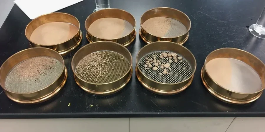
Full sieve stack plus hydrometer
Complete mechanical sieve analysis from coarse gravel down to No. 200, plus hydrometer sedimentation for the silt and clay fraction. You get a grain size distribution curve, USCS classification per ASTM D2487, and tabulated D10/D30/D60 values for uniformity and curvature coefficients.
Lab report with classification summary
Each report includes the gradation curve plotted semi-log, percent gravel/sand/silt/clay breakdown, and the USCS group symbol. We add notes on any gap-grading, fines content thresholds that trigger Atterberg testing, and drainage implications relevant to Glendale's monsoon conditions.
Typical parameters
Common questions
What does a grain size analysis cost in Glendale?
For a standard sieve plus hydrometer package, you're looking at US$90 to US$180 depending on fines content and whether we need to run the full sedimentation procedure. Clean sands with less than 5 percent fines run on the lower end; silty or clayey soils that require extended hydrometer readings push toward the upper end. We'll give you a firm number once we see the sample.
How long does the hydrometer portion actually take?
The hydrometer sedimentation phase runs a minimum of 24 hours for the full reading series, because clay-size particles settle slowly and ASTM D422 requires readings at specific time intervals—0.5, 1, 2, 4, 8, 15, 30, 60 minutes, then 2, 4, and 24 hours. Add sieve drying and weighing, and the complete analysis wraps in 2 to 3 business days.
Do you need a hydrometer test if the soil looks sandy?
Yes, and here's why: even a soil that feels gritty to the touch can carry 10 to 15 percent fines that don't show up until you wash it through the No. 200 sieve. In Glendale, those fines are often low-plasticity silts that affect compaction curves and drainage. Skipping the hydrometer on a sandy soil with borderline fines content is how you end up with a foundation designed for the wrong soil class.
What sample size do you need from the field?
We need about 500 grams for sandy soils and 200 grams for fine-grained material, but honestly, bring us a gallon bag and we'll split it in the lab. The key is that the sample is representative—if your trench exposes two different layers, bag them separately and label the depths. Mixed samples from different strata give you a gradation curve that doesn't represent anything real.
Can you classify the soil from just the grain size data?
The sieve and hydrometer data give us the USCS classification per ASTM D2487 for coarse-grained soils, but if the fines content exceeds 12 percent, we need Atterberg limits to assign the correct dual symbol. So for clean sands and gravels, yes; for silty or clayey sands, the grain size analysis tells us we need the Atterberg data to finish the classification properly. More info.