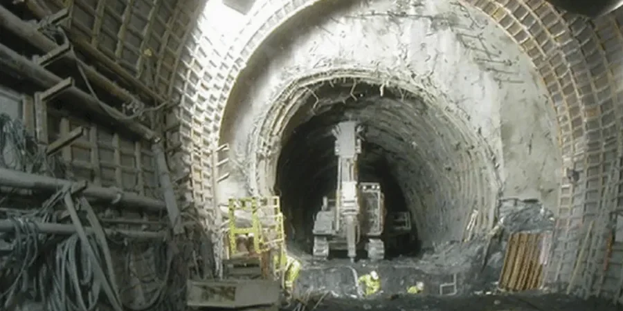
Tunneling through the Salt River Valley’s basin-fill deposits demands more than standard subsurface data. Glendale sits on a deep alluvial basin where interbedded silts, clays, and loose sands can transition within a few vertical feet—a condition that ASCE 7 and IBC Chapter 18 classify as Site Class D or E depending on shear wave velocity. In our experience, the biggest headache for contractors is not the excavation itself but the face instability that shows up when pore pressures go unaccounted. That’s why our geotechnical analysis for soft soil tunnels starts with high-quality sampling per ASTM D1586, paired with lab index testing under ASTM D2487, so the unified classification feeds directly into the ground model. For deeper segments where SPT refusal is rare, coupling the investigation with a CPT test gives continuous tip resistance and sleeve friction profiles that help refine the stand-up time estimate before the TBM ever arrives on site.
Face instability in Glendale’s basin-fill silts often traces back to one overlooked variable: pore pressure response during the monsoon wetting front.
Our approach and scope
Local considerations
The basin-fill geology underneath Glendale doesn’t announce its weak spots. Paleochannels of the Salt and Agua Fria rivers left behind disconnected lenses of loose, saturated sand that can liquefy under seismic shaking—and the city sits within a region where the USGS national hazard model assigns a 10% probability of exceeding 0.15g peak ground acceleration in 50 years. When a tunnel boring machine hits one of those lenses without a pre-injection program, the face can slough in seconds, trapping the cutterhead and delaying the schedule by weeks. We’ve also encountered perched groundwater perched atop a buried caliche layer at roughly 20 feet depth on the west side of Loop 101; it’s not mapped on any USGS quad, but it’s real and it complicates dewatering. Mapping those lenses early with seismic refraction lets us flag the velocity inversions that signal loose, saturated zones before the TBM commits to the alignment.
Reference standards
IBC 2021 Chapter 18 (Soils and Foundations), ASCE 7-22 Minimum Design Loads for Buildings and Other Structures, ASTM D1586 Standard Test Method for Standard Penetration Test (SPT), ASTM D2487 Standard Practice for Classification of Soils for Engineering Purposes (Unified Soil Classification System), ASTM D4318 Standard Test Methods for Liquid Limit, Plastic Limit, and Plasticity Index of Soils
Related services
Tunnel Face Stability Assessment
We combine SPT borings, CPT soundings, and laboratory triaxial testing to back-calculate the undrained shear strength profile along the proposed alignment. The output feeds directly into TBM operating parameters—face pressure, screw conveyor speed, and conditioning agent ratios—so the contractor isn’t guessing when they hit the silty-sand transition.
Pre-Excavation Grouting Design
In Glendale’s paleochannel reaches, we map the lens geometry with geophysics, then design a permeation or compensation grouting program using the in-situ permeability values from field falling-head tests. The goal is a treated zone that gives at least 48 hours of stand-up time before the cutterhead reaches it.
Typical parameters
Common questions
What is the typical cost range for a geotechnical investigation before soft-ground tunneling in Glendale?
For a typical tunnel alignment study in the Glendale area, the geotechnical investigation phase generally runs between US$4,430 and US$15,560. The final figure depends on how many boreholes are needed, whether CPT soundings are added to fill gaps between borings, and how much laboratory testing—triaxial, consolidation, or permeability—the ground model requires. Alignments that cross known paleochannels usually push toward the upper end because you need tighter station spacing to catch the lens boundaries.
How does the basin-fill geology in Glendale affect TBM selection?
The interbedded silts and sands with occasional gravel lenses tend to favor earth pressure balance (EPB) machines over open-face shields. EPB TBMs can regulate face pressure through the screw conveyor, which helps when you transition from a stiff, overconsolidated clay into a loose, saturated sand within the same drive. The gravel lenses, though infrequent, can cause abrasive wear on the cutterhead, so we typically recommend a disc cutter inspection plan based on the percentage of GW material logged in the borings.
Do you run consolidation tests for the soft clays found under Glendale?
We do. Oedometer consolidation tests on Shelby tube samples let us determine the compression index (Cc) and the preconsolidation pressure for the basin clays. That data matters because if the clay is normally consolidated, the tunnel crown can settle more than expected once the groundwater regime is disturbed. The consolidation parameters feed directly into the settlement trough prediction, which affects the surface easement and utility relocation planning.
What geophysical methods complement the borings for tunnel work here?
We often run MASW (Multichannel Analysis of Surface Waves) lines along the proposed alignment to get a continuous Vs30 profile, which nails down the IBC Site Class and also helps spot velocity inversions that hint at loose, saturated pockets. In areas with a shallow caliche cap that blocks the surface waves, we switch to seismic refraction, which handles the high-velocity top layer better and still gives us a usable P-wave tomogram.
How do you handle groundwater surprises during the investigation?
Glendale’s groundwater table is notoriously variable because of the perched zones above caliche layers and the seasonal monsoon influence. We install vibrating-wire piezometers in at least two boreholes per alignment segment and log readings through a full wet-dry cycle if the schedule allows. That time-series data is what tells us whether the water we hit is a true aquifer or just a perched lens that will drain once the tunnel passes through it.